Spitzkoppe, Namibia

Way back when I was first interested in the Nature’s Light trip to Namibia I was admittedly a little sceptical about spending two full days at the rocky Spitzkoppe. I even emailed them to query why, given the other stunning locations in Namibia, we were spending so much time there. “It’s always popular with those who have been. Don’t worry, you’ll see.” was the reply. Sceptical I remained.

Time passed and a few months later and I found myself at Spitzkoppe and have to admit that my concerns were unfounded. Despite my dubbing it “The Rock” once I saw beyond the immensity of the mountain itself, it was the little details that really stood out.

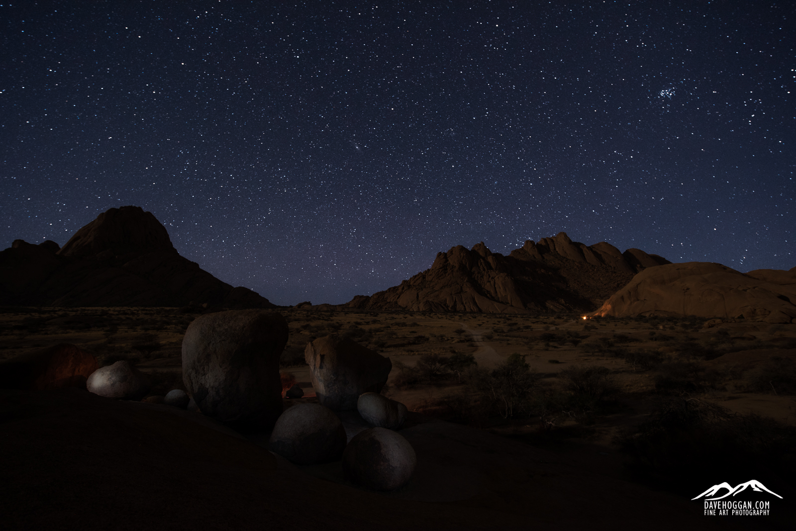
This is the final shot taken on the trip. We had just finished shooting some timelapses and panoramas at a rock arch (behind me in this shot) and were relaxing with a beer (or perhaps two). Looking out over the plain to Gross Spitzkoppe (left) and the Pontok range (right), we could see the glow of camp fires casting their glow on the rock faces. The canopy of stars, like everywhere else in Namibia, was incredible.

Spitzkoppe Stars

Posted in Frame by Frame Tagged , , , , |

Namib Desert, Namibia

If there is one thing I take home with me from the recent trip to Namibia it is the sand – literally. Even in the final days of the trip when we were inland at Spitzkoppe, I found myself suddenly chewing sand that had miraculously appeared from nowhere, and after cleaning out the camera bag on the last night I still managed to shower the lady sitting in the seat in front of me on the plane home with it when placing the bag in the overhead storage bins.

Sand was unavoidable as we spent the bulk of the trip in the Namib Desert, a coastal desert that separates the Atlantic Ocean from the more habitable inland for the entire length of the Namibian coast. It is considered to be most likely the oldest desert on Earth and, with dunes rising to over 300 metres and 32 km long, one with the second largest dunes. Like most deserts, the temperatures vary from unbearably hot during the day to bitterly cold at night. And, like most deserts, it is a beautiful, ever-changing landscape.

This shot was taken when returning from a night shoot at Deadvlei – a forest of trees that died approximately 600 years ago but did not decompose due to the arid air of the surrounding desert. What remains are the desiccated skeletons of the trees. By 6AM the light was too bright for the astrophotography we were doing and we spent an hour in the pre-dawn light before heading back to the jeep. As we were leaving the first visitors were arriving and some were heading up the dune just as sunrise fell across the land setting fire to the red sands.

Namib Desert Dune


Posted in Frame by Frame Tagged , , , |

Bruarfoss, Iceland

Bruarfoss became, quite frankly, a bit of an obsession.

In the months leading up to the return trip to Iceland this year I knew that I really wanted to visit Bruarfoss. It is one of those oddities in travel – a hidden gem off the tourist path that, despite its beauty, no one seemed to talk about.

As I researched it I began to understand why it is, at least so far, off most visitors radar. First, despite being located near one of the busiest tourist roads in Iceland, route 37 that travels right past Geysir, it is located down a potholed, mostly single-lane dirt track that prevents coaches from getting near. As most visitors to Iceland tend to be those that base themselves in Reykjavik and take day trips to the various sights, this pretty much eliminates most visitors from seeing Bruarfoss. For those that do venture out and hire a vehicle (and I feel confident in suggesting a normal 2WD car driven carefully would be fine) finding it is the biggest challenge. Looking at Google Maps there are three possible paths that each take the intrepid driver on a windy path through what appears to be a summer home area, which apparently it is. Turn to the Internet and matters become more confusing as some people suggest one route, with others countering that the route is not possible as the track has a barrier across it and that you need to go another way instead – a suggestion that yet more people disagree with. It doesn’t help that the Google Maps road overlay has inaccuracies either. I spent untold hours over a couple of months trying to find instructions that any two people agreed upon. I failed.

For me, with two days set aside for the Bruarfoss area, it was frustrating – I didn’t want to spend a half-day just trying to find the place – but for those don’t have the luxury of such time, I can see them either being put off altogether or simply running out of time trying to find it. Which is a real shame as it is, quite simply beautiful.

Bruarfoss #1


Posted in Frame by Frame Tagged , , , |

Kirkjufell & Kirkjufellfoss, Iceland.

As impressive as the waterfalls in Iceland generally are, you can’t help but getting a little blasé by the time you’ve marvelled at the first thirty or forty. In fact, barring a particularly deep-rooted passion for waterfalls, by the end of a couple of weeks you’ll find yourself largely not noticing them.

And so it would be with the rather unassuming Kirkjufellfoss, a modest waterfall just west of Grundarfjörður on the Snæfellsnes peninsula. Bluntly, after you’ve visited some of the other waterfalls on the usual itinerary, it wouldn’t really warrant a stop were it not for the striking presence of the nearby Kirkjufell mountain.

Despite nature conveniently placing the two next to each other it is a surprisingly difficult combination to photograph simply as (1) it has been photographed by thousands of photographers already and (2) there is always a hoard of photographers lined up trying to capture an interesting angle not already captured by one of the aforementioned thousands of photographers.

This shot was taken close to sunset on one of the few days where the cloud cover on the peninsula broke enough to allow shadows to dance across the land and illuminate Kirkjufell.

Kirkjufell 1600px

Posted in Frame by Frame Tagged , , , , |

The Clouds, Iceland.

Sometimes you look up from what you’re doing (driving in my case) and see a scene that so completely reminds you of something that you can’t see anything else. So it was when driving along route 37 in Iceland looking for a building with a shiny metal roof for a composition I had in my head. The moment I saw I it knew what I saw and now can’t see anything else – probably a testament to the state of my mind more than anything.  In fact, if Rorschach hadn’t opted for using ink blots I’m pretty sure he’d have used clouds.


The Clouds, Iceland

Posted in Frame by Frame Tagged , , , , |

Gatklettur, Iceland.

Whilst in Iceland earlier this month my time on the Snæfellsnes peninsula was frustrated by some decidedly wet and windy weather, so windy that on some days the water of the waterfalls was being blown straight back up the cliff face back to where it had just come from. When it wasn’t raining or blowing so hard that it defied gravity, the sky was usually a rather dull and featureless white due to the clouds gathering around the high mountain peaks.  So, when the cloud cover broke and some level of detail returned to the sky it was a bit of a mad dash around the peninsula to visit some of the more interesting sites.

Once such place is Gatklettur, a rock arch walking distance from the village of Arnarstapi on the southern coast of the peninsula. There is a gentle hike along the coast between Arnarstapi and Hellnar that has some wonderful rock formations, but Gatklettur is perhaps the most visually interesting with its horseshoe arch and near perfectly circular ‘window’. It is frequently photographed and it is really tempting to photograph it as an incoming wave crashes against its seaward side and water erupts from the circular hole. So I did.

But I favour this, the aftermath where the white foam of the water cascades down the basalt rock, picking out a path over the jagged steps.

Gatklettur, Iceland

Posted in Frame by Frame Tagged , , , , |

Iceland’s Route 574

Route 574 on the Snæfellsnes peninsula in the west of Iceland. It’s a sparsely populated and barren area dominated by the central spine of high peaks ending in Snæfellsjökull volcano made famous by the Jules Verne novel Journey to the Centre of the Earth. Clouds gather and can linger for days. Not always great conditions for photography but it creates a great mood.

I’ve been after a decent “road” shot for a while and drove along this stretch a few times. The barren landscape and dark clouds dictated a black and white conversion, but I didn’t want to lose the yellow roadside markers so I added them back in after the conversion. I don’t like a lot of post processing (laziness can be a gift!) but in this case the image is stronger for it.

It’s a beautiful place…

Many tourists worry about driving in Iceland, but other than around the capital Reykjavik, this is as busy as the roads get.

Many tourists worry about driving in Iceland, but other than around the capital Reykjavik, this is as busy as the roads get.

Posted in Frame by Frame Tagged , , , |

The Iceland Trip’s “Worst Case Scenario”

With the trip to Iceland being tomorrow and packing essentially complete I’m now at the point where I’m actually beginning to get excited. In fact there are only a few items left to deal with, including buying a few of those “meals in a bag” for the middle of the trip when I’m up in the Icelandic highlands and nowhere near a supermarket. That’s the double-edged nature of Iceland: It’s a truly breath-taking country but it favours the prepared.

Now, I do consider myself a reasonably prepared traveller, including the steps I take to stay out of trouble. But a recent post by a regular contributor over on the Trip Advisor Iceland forum did stop me in my tracks. In it she suggested that the profile for those travellers to Iceland that end up never leaving (alive) is male, a solo traveller, hiking and often with some experience. I fit 100% into that profile and whatever the source of this statistic I found myself double-checking my preparations for a “worst-case scenario”.

Risk analysts with tell you that there are three ways to deal with risk: Accept it and carry on (assume the risk), take steps to reduce the risk (mitigate the risk) or get someone else to handle the risk (transfer the risk). Depending upon the situation each option can be a valid approach, but in the case of my time in Iceland’s highland interior as the predictably unpredictable weather continues to worsen, option one would be plain, flat-out, stupid and option three (in this case meaning going on an organised trip) would be too expensive – if possible at all – and so inflexible as to render the reason for being there not worthwhile. So it was time to take the middle ground.

It is worth pointing out that there are usually three potential sources of danger in a given environment: From other humans, from animals and from nature itself. In Iceland you can disregard the first two completely. If anything is going to cause you problems, it will be the weather.

Staying on the Grid

The first thing to mention is telecommunication. Iceland has excellent mobile phone coverage from a number of operators. For example, take a look at Vodafone Iceland’s GSM coverage:

Everybody love 4G but despite being “so last century” GSM is your new best friend in Iceland.

Everybody loves 4G but despite being “so last century” GSM is your new best friend in Iceland.

So, should the worst happen I’m more than likely going to have access to the outside world, but who am I going to call?

Perhaps the obvious would be friends or family back home. If I had no other alternative then, well, I have no other alternative but I’m not going to be calling for a chat – I’m going to be having an emergency. If you’ve ever tried it trying to organise a rescue for someone from another country it is very difficult and as time is the enemy here, I really I don’t want to be in that position. So I’m making sure that I have the phone numbers for my accommodation in Iceland and confirming my arrival with each of them on the morning of arrival.

An example of why making sure that the accommodation knows you’re definitely arriving is useful happened to me back in 2010. We were taking a 4WD from the village of San Pedro de Atacama in northern Chile to the town of Uyuni in southern Bolivia. It’s a route taking three days and involves travelling through the northern Andes at an altitude of 4,500 metres. It’s a barren, unending wilderness where the temperature drops to -15°C or below once the sun goes down.

It is official – the fuel pump is dead. At 4,500 metres altitude that's not what you want to hear...

It is official – the fuel pump is dead. At 4,500 metres altitude that’s not what you want to hear…

Due to contaminated fuel the fuel pump died stranding us on the second day. Despite having been told otherwise there was no radio to call for help – and mobile phones were definitely out – and it was only because we were on a route that other 4WD vehicles used that we were able to ask a passing driver to let people know we needed help once he arrived back in civilisation. Which he didn’t do.

Luckily the accommodation we were staying in that evening were expecting us and when we didn’t show up they contacted the company who had organised our arrival and help was sent overnight to look for us. It was an uncomfortable evening – and we missed out on seeing some spectacular sights due to the delay – but we were rescued because of the accommodation raising the alarm.

In Iceland you have other tools at your disposal. The completely free 112 app from safetravel.is and available for iOS, Android and Windows mobile devices allows you to keep in contact by letting the emergency services know your location. It’s simple to use and works by sending a SMS text message so doesn’t need 3G or 4G to operate, hence why I showed the GSM coverage map above – it’s all the app needs to work.

Free, easy to use and could possibly save your life. What's not to like?

Free, easy to use and could possibly save your life. What’s not to like?

How you use it is up to you this but I just set my watch to remind me every 30 minutes to check-in. That way if the worst were to happen then the emergency services know my approximate location.

So, letting people know is very, very important and Iceland makes it so easy to do that there is no excuse not to do so. It is a zero-cost option for having someone looking out for me. I’d be stupid not to use it.

Of course, should I find myself needing assistance I’m likely going to have to wait until help arrives. For my trip I’ve considered three scenarios when travelling by myself: (1) The 4WD breaks down (2) I’m out hiking  and the weather unexpectedly turns for the worse and I end up in a biting cold storm with very low visibility or (3) I sprain an ankle. Each of these conditions is quite possible and can be life-threatening if not prepared.

The “Car Breaks Down” Scenario

The ‘car breaks down’ scenario is a relatively easy one to deal with: Phone the car hire company. However, it may be that they cannot rescue me quickly and so I have to spend the night in the car. That’s where my trusty Alpkit SkyeHigh 600 sleeping back comes in. Rated down to -5°C it means that an evening stuck inside the car out of the wind and rain inside will also be a warm one and a break-down becomes an annoyance rather than dangerous.

The “Bad Weather” Scenario

Due to its geography and location the weather in Iceland can change exceptionally quickly, especially in the highlands, and so the best course of action is to assume the worst. For me this entails being out hiking in the highlands of Kerlingarfjoll and a sudden snow or rain storm comes in and reduces visibility to near zero.

Cold! The red rectangle shows the highland area that I’ll be hiking in.

Cold! The red rectangle shows the highland area that I’ll be hiking in.

The first common-sense thing to do is check the weather forecast. It’s not accuracy that I’m after but rather a general idea and as can be seen in the above image from vedur.is – Iceland’s meteorological office – Kerlingarfjoll is going to be reaching sub-zero temperatures and so I need to ensure that I can keep warm and dry when out-and-about.

The easiest way to dress for the occasion is to use the layering principle of clothing (if you’ve not come across this then Google ‘layering principle clothing’). This is a tried-and-tested method of ensuring that your clothing suits your environment and in the highlands the outer waterproof and windproof layer is as important as the warmth-providing base and mid layers. Easy things to forget are gloves and some kind of hat.

I am pretty confident in my clothing and I’m happy that it will cope with the extremes of Iceland’s weather that I’ll be facing – it better as 66 North is an Icelandic outdoor brand – but I’m definitely following the advice of many experts who recommend avoiding jeans and cotton as, when wet, they don’t dry quickly and in a cold environment they can accelerate the cooling of your body and speed up the onset of hypothermia.

So, should the weather turn nasty, it won’t present an immediate danger and I’ll be warm and dry enough to get back to camp. Assuming I can find camp!

GPS used to be the tool of the seasoned outdoor adventurer but smart phones have put this powerful navigational tool into the hands of just about everybody. GPS apps are available for all brands of smart phone and, given that the software is cheap – and you can have a lot of fun later by downloading the data to your PC and showing your friends and family exactly where you hiked on Google Maps – it makes sense to invest in the app.

The display may look a little unfriendly but there are also options to download Google Maps data and use if when away from 3G/4G mobile coverage. You can then watch your route unfold as you walk.

The display may look a little unfriendly but there are also options to download Google Maps data and use if when away from 3G/4G mobile coverage. You can then watch your route unfold as you walk.

I use an old iPhone 4S with no SIM card and running a dedicated GPS app – in this case GPS Kit. Other than the obvious ability to pinpoint my location it also has a tracking option that will allow me to backtrack without having to rely on visible clues such as path markers should I need to. The phone is in a rugged, waterproof case (by Lifeproof) that I picked up second-hand on eBay so there is no worry about using it in rain or snow. I’ve actually tested the waterproof nature having been diving with it to a depth of 12 metres so it doesn’t matter how bad the rain gets, it won’t be worse than that! I’ve also got a portable USB battery pack that is small enough to be easy to carry but can charge the iPhone twice over.

The “Injured” Scenario

The most likely form of injury when out hiking is a sprained ankle, especially when walking over uneven ground. Anyone who has had a sprained ankle will tell you how painful it can be, but when out-and-about by yourself it can be deadly. Back in 2008, when I was preparing to walk the wild section of the Great Wall of China, I relied a lot on the local knowledge of a photographer based out there and his advice as simple: Do not walk it alone. People have died after an injury and not being found for a couple of weeks. The good news is that in Iceland’s highlands you wouldn’t have to suffer that long – a night would probably be enough to finish you off.

There’s a reason that the “Wild Wall of China” is closed to hikers.

There’s a reason that the “Wild Wall of China” is closed to hikers. This was a complete section until someone walked on it…

The single best piece of advice I have been given for hiking is to wear properly fitted walking boots that support your ankle. This does not necessarily mean the most expensive walking boots you can find – my current boots were significantly cheaper than all the others I was considering but they hold my feet securely. Looking where you are going and not rushing is good advice too. As my clothing is going to keep me warm and dry, I have no need to rush and anyway, having 10kg of camera gear to carry always slows you down.

No, should the weather turn nasty and visibility fail, the only thing that will likely kill me is panic.

But should it happen there are a number of tips for dealing with a sprained ankle and whilst I have a plan the simple fact of the matter is that the injury scenario is really one of those where my best hope of survival is the steps I will have already taken that day and outlined above. In the case of my stay at Kerlingarfjoll in the highlands my plan is simple:

  1. Each morning tell hotel the route I’m taking, when I expect to be back and that I will check in with reception on my return.
  2. I’ll also double-check the weather that day – local knowledge is always good.
  3. Use the 112 app.
  4. Use the GPS app to plot my route.
  5. Don’t rush and watch where I’m going.

Of course, I have my Icelandic “worst-case scenario” kit-bag (which is really just my usual travel kit with a dramatic name)  which contains a few, cheap, lightweight items – along with a couple of larger items I use in photography.

  • Strong painkillers
  • Sprain bandage
  • Spare bootlaces (handy for so many things, including boots!)
  • Emergency stitches (also called suture strips)
  • Liquid plaster (a paint-on anti-sceptic plaster)
  • Plasters
  • Compede (a UK brand of blister plaster)
  • Scissors
  • Tweezers
  • Survival blanket
  • Gaffer tape (carried due to its use for photography, but handy for splints)
  • GPS
  • USB power brick
  • LED Torch (again, used for light painting in photography but has a 20 hour charge)
  • Swiss Army Penknife (well, it’s not proper hiking without one!)

Despite seeming a large and costly list, the medical bits all fit into sunglasses case so really easy to carry around in a pocket or backpack.

At the end of the day you can never plan for every eventuality. What you can do is identify the potential dangers and plan as best you can around them. That’s usually the difference between trips that have “moments” that to tell your friends about for years afterwards and those trips that are your last.

Posted in Travel, Trip Planning, Uncategorized Tagged , , , |

Brighton Pier, UK.

The skeletal remains of the old pier.

Brighton Pier 2015


Posted in Frame by Frame Tagged , , , |

Northern Andes Mountain range, 2010.

A lone 4WD rushes to the only structure in the area – a stone-built refuge – at sunset as darkness spreads across the land. At an altitude of 4,300 metres on the Bolivian altiplano nightfall means -15°C temperatures.

Tocotacape, Bolivia.

Posted in Frame by Frame Tagged , , |
Iowa shipping sustiva Nebraska shipping keflex 250mg Where to buy xyzal in Raleigh Madison diflucan shipping Vancouver allopurinol shipping Buy trazodone from Raleigh What is xtandi Buspar heartburn Buy starlix 60mg from Nashville Buy sustiva online from Victoria