Monthly Archives: November 2015

Quiver Tree Forest, Namibia

The Quiver tree forest near Keetmanshoop in southern Namibia likely won’t win any awards for accurate advertising.

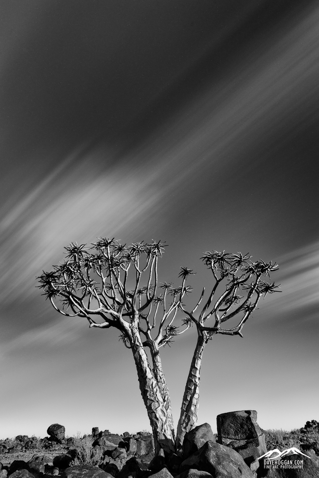
For a start, they’re not really trees – they’re aloe – although decades and, in some cases, centuries of growth have seen them rival trees in size and shape. Second, to call it a forest is a bit of a stretch and even the moniker ‘wood’ would be a little over optimistic. Still, you can wander between them and when I was trying to find a lone quiver tree to photograph there was always at least one lurking on the background somewhere. But they do quiver, although Wikipedia suggests that the name comes from the fact that local bushmen used their branches to make quivers for hunting.

We were out for our final visit to the forest with the aim of catching the light from the setting sun before settling in for an evening of astrophotography. As I wandered further away the already sparse trees became more isolated and I was immediately struck by a three-trunked tree close to the edge of a plain extending, empty and unyielding, into the distance. The light wasn’t great and the sky was a clear and featureless blue but I made a note to walk back past this tree in a couple of hours thinking that I could add interest to the sky by using a polariser to bring out different shades of blue and then convert to black and white.

Upon my return I have to say that I was pretty happy to find that the sun was now low enough to cast areas of shadow around the tree and light up the wonderfully textured bark. I was even more happy to see that not only were there finally some clouds in the sky but the wind was moving quickly enough for them to blur on a long exposure. In fact, I may have even performed a mini fist pump at my luck, but with no one to witness it, I still have plausible deniability.

The only downside of the 30 second exposure and the wind blowing the clouds across the sky is that I discovered the other reason why the trees are called quiver trees.

Quiver #1 1600px


Posted in Frame by Frame Tagged , , , , |

Spitzkoppe, Namibia

Way back when I was first interested in the Nature’s Light trip to Namibia I was admittedly a little sceptical about spending two full days at the rocky Spitzkoppe. I even emailed them to query why, given the other stunning locations in Namibia, we were spending so much time there. “It’s always popular with those who have been. Don’t worry, you’ll see.” was the reply. Sceptical I remained.

Time passed and a few months later and I found myself at Spitzkoppe and have to admit that my concerns were unfounded. Despite my dubbing it “The Rock” once I saw beyond the immensity of the mountain itself, it was the little details that really stood out.

This is the final shot taken on the trip. We had just finished shooting some timelapses and panoramas at a rock arch (behind me in this shot) and were relaxing with a beer (or perhaps two). Looking out over the plain to Gross Spitzkoppe (left) and the Pontok range (right), we could see the glow of camp fires casting their glow on the rock faces. The canopy of stars, like everywhere else in Namibia, was incredible.

Spitzkoppe Stars

Posted in Frame by Frame Tagged , , , , |

Namib Desert, Namibia

If there is one thing I take home with me from the recent trip to Namibia it is the sand – literally. Even in the final days of the trip when we were inland at Spitzkoppe, I found myself suddenly chewing sand that had miraculously appeared from nowhere, and after cleaning out the camera bag on the last night I still managed to shower the lady sitting in the seat in front of me on the plane home with it when placing the bag in the overhead storage bins.

Sand was unavoidable as we spent the bulk of the trip in the Namib Desert, a coastal desert that separates the Atlantic Ocean from the more habitable inland for the entire length of the Namibian coast. It is considered to be most likely the oldest desert on Earth and, with dunes rising to over 300 metres and 32 km long, one with the second largest dunes. Like most deserts, the temperatures vary from unbearably hot during the day to bitterly cold at night. And, like most deserts, it is a beautiful, ever-changing landscape.

This shot was taken when returning from a night shoot at Deadvlei – a forest of trees that died approximately 600 years ago but did not decompose due to the arid air of the surrounding desert. What remains are the desiccated skeletons of the trees. By 6AM the light was too bright for the astrophotography we were doing and we spent an hour in the pre-dawn light before heading back to the jeep. As we were leaving the first visitors were arriving and some were heading up the dune just as sunrise fell across the land setting fire to the red sands.

Namib Desert Dune


Posted in Frame by Frame Tagged , , , |

Bruarfoss, Iceland

Bruarfoss became, quite frankly, a bit of an obsession.

In the months leading up to the return trip to Iceland this year I knew that I really wanted to visit Bruarfoss. It is one of those oddities in travel – a hidden gem off the tourist path that, despite its beauty, no one seemed to talk about.

As I researched it I began to understand why it is, at least so far, off most visitors radar. First, despite being located near one of the busiest tourist roads in Iceland, route 37 that travels right past Geysir, it is located down a potholed, mostly single-lane dirt track that prevents coaches from getting near. As most visitors to Iceland tend to be those that base themselves in Reykjavik and take day trips to the various sights, this pretty much eliminates most visitors from seeing Bruarfoss. For those that do venture out and hire a vehicle (and I feel confident in suggesting a normal 2WD car driven carefully would be fine) finding it is the biggest challenge. Looking at Google Maps there are three possible paths that each take the intrepid driver on a windy path through what appears to be a summer home area, which apparently it is. Turn to the Internet and matters become more confusing as some people suggest one route, with others countering that the route is not possible as the track has a barrier across it and that you need to go another way instead – a suggestion that yet more people disagree with. It doesn’t help that the Google Maps road overlay has inaccuracies either. I spent untold hours over a couple of months trying to find instructions that any two people agreed upon. I failed.

For me, with two days set aside for the Bruarfoss area, it was frustrating – I didn’t want to spend a half-day just trying to find the place – but for those don’t have the luxury of such time, I can see them either being put off altogether or simply running out of time trying to find it. Which is a real shame as it is, quite simply beautiful.

Bruarfoss #1


Posted in Frame by Frame Tagged , , , |
Vancouver allopurinol shipping What is xtandi Buy alphagan online from Frankfort Buy trazodone from Raleigh Where to buy caverta online in Delaware Singulair heavy heartbeat Madison diflucan shipping Nebraska shipping keflex 250mg Generic caverta from Alberta